
La Independencia topographic map
Interactive map
Click on the map to display elevation.
About this map
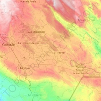
Name: La Independencia topographic map, elevation, terrain.
Location: La Independencia, Chiapas, Mexico (16.12169 -92.05118 16.30566 -91.49998)
Average elevation: 1,458 m
Minimum elevation: 565 m
Maximum elevation: 2,476 m
Other topographic maps
Click on a map to view its topography, its elevation and its terrain.
Tuxtla Gutiérrez
Mexico > Chiapas > Tuxtla Gutiérrez
On the edge of the city is the El Zapotal Ecological Reserve, best known as the home of the Zoológico Miguel Alvarez del Toro Zoo, often referred to as the ZooMAT. The zoo covers 100 hectares and was founded by Miguel Alvarez del Toro in 1942. He was also the director for over fifty years. ZooMAT is…
Average elevation: 817 m