
Vahrn topographic map
Interactive map
Click on the map to display elevation.
About this map
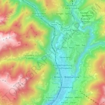
Name: Vahrn topographic map, elevation, terrain.
Location: Vahrn, Eisacktal, Bozen, Trentino-Südtirol, Italien (46.70635 11.48513 46.78173 11.65833)
Average elevation: 1,257 m
Minimum elevation: 543 m
Maximum elevation: 2,513 m
Der zu Vahrn gehörende Bereich des Eisacktals befindet sich im Nordwesten des Brixner Talkessels am Ausgang des Wipptals. Der Hauptort Vahrn liegt auf 650 m Höhe auf der orographisch rechten, westlichen Seite des Eisack und nimmt dort den Schwemmkegel des Schalderer Bachs ein. Auf der gegenüberliegenden Flussseite befindet sich die Fraktion Neustift (600 m).
Other topographic maps
Click on a map to view its topography, its elevation and its terrain.
Gaishorn
Italien > Trentino-Südtirol > Vahrn
Gaishorn, Vahrn, Eisacktal, Bozen, Trentino-Südtirol, Italien
Average elevation: 2,231 m