
Make a donation
Gear up for your next adventure:
As an Amazon Associate, this site earns from qualifying purchases at no extra cost to you.
Weehawken topographic map
Click on the map to display elevation.
Make a donation
Gear up for your next adventure:
As an Amazon Associate, this site earns from qualifying purchases at no extra cost to you.
Weehawken
While the Palisades defines Weehawken's natural topography, the Lincoln Tunnel Helix is prominent man-made and Lincoln Tunnel toll plaza are prominent man-made structures. Geographically, Weehawken has distinct neighborhoods: Downtown (known as "The Shades"), the Heights, Uptown (which includes Kingswood Bluff, known as "The Bluff"), and the Waterfront, which since the 1990s has been developed for transportation, commercial, recreational and residential uses. Though some are long abandoned (e.g., Grauert Causeway), there are still several outdoor public staircases (e.g., Shippen Steps) throughout the town and more than 15 "dead-end" streets. At its southeastern corner is Weehawken Cove which, along with the rail tracks farther inland, defines Weehawken's border with Hoboken. Its northern boundary is shared with West New York. Traversing Weehawken is Boulevard East, a scenic thoroughfare offering a sweeping vista of the Hudson River and the Manhattan skyline. Local zoning laws prohibit the construction of high-rise buildings that would obstruct sight-lines from higher points in the township. In a 1999 decision that blocked the development of a pair of waterfront towers that would have stood 160 feet (49 m), a judge cited the panoramic vistas from Weehawken as "a world-class amenity that encourages people to live, work and locate businesses in the area". In 2021, the development company Roseland donated 14.5 acres (5.9 ha) of land on the Palisades cliff face to the town in order to preserve its beauty and its history.
Make a donation
Gear up for your next adventure:
As an Amazon Associate, this site earns from qualifying purchases at no extra cost to you.
About this map
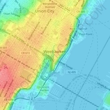
Name: Weehawken topographic map, elevation, terrain.
Location: Weehawken, Hudson County, New Jersey, 07086, United States (40.75666 -74.03270 40.78072 -74.00162)
Average elevation: 27 m
Minimum elevation: -2 m
Maximum elevation: 80 m
Make a donation
Gear up for your next adventure:
As an Amazon Associate, this site earns from qualifying purchases at no extra cost to you.
Other topographic maps
Click on a map to view its topography, its elevation and its terrain.
Croxton
United States > New Jersey > Hudson County > Jersey City > Journal Square
Average elevation: 16 m
Make a donation
Gear up for your next adventure:
As an Amazon Associate, this site earns from qualifying purchases at no extra cost to you.
North Hudson Park
United States > New Jersey > Hudson County > North Bergen > Hudson Heights
Average elevation: 41 m
Make a donation
Gear up for your next adventure:
As an Amazon Associate, this site earns from qualifying purchases at no extra cost to you.
Bergen Square
United States > New Jersey > Hudson County > Jersey City > Journal Square
Average elevation: 13 m
Marion
United States > New Jersey > Hudson County > Jersey City > Journal Square
Average elevation: 12 m
Make a donation
Gear up for your next adventure:
As an Amazon Associate, this site earns from qualifying purchases at no extra cost to you.
Croxton
United States > New Jersey > Hudson County > Jersey City > Journal Square
Average elevation: 16 m
Make a donation
Gear up for your next adventure:
As an Amazon Associate, this site earns from qualifying purchases at no extra cost to you.
Hudson River Waterfront
United States > New Jersey > Hudson County > Jersey City
Average elevation: 2 m
North End Business District
United States > New Jersey > Hudson County > Secaucus
Average elevation: 4 m
Bergen Square
United States > New Jersey > Hudson County > Jersey City > Journal Square
Average elevation: 13 m
Make a donation
Gear up for your next adventure:
As an Amazon Associate, this site earns from qualifying purchases at no extra cost to you.