
Make a donation
Gear up for your next adventure:
As an Amazon Associate, this site earns from qualifying purchases at no extra cost to you.
Roxbury topographic map
Click on the map to display elevation.
Make a donation
Gear up for your next adventure:
As an Amazon Associate, this site earns from qualifying purchases at no extra cost to you.
About this map
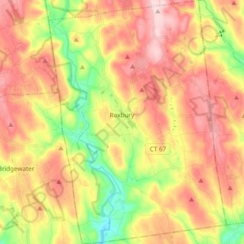
Name: Roxbury topographic map, elevation, terrain.
Average elevation: 199 m
Minimum elevation: 59 m
Maximum elevation: 321 m
Make a donation
Gear up for your next adventure:
As an Amazon Associate, this site earns from qualifying purchases at no extra cost to you.
Other topographic maps
Click on a map to view its topography, its elevation and its terrain.
Apple Hill
United States > Connecticut > Northwest Hills Planning Region > Morris
Average elevation: 297 m
Northfield
United States > Connecticut > Northwest Hills Planning Region > Litchfield
Average elevation: 259 m
Bakerville
United States > Connecticut > Northwest Hills Planning Region > New Hartford
Average elevation: 244 m
Haystack Mountain
United States > Connecticut > Northwest Hills Planning Region > Norfolk
Average elevation: 385 m
Make a donation
Gear up for your next adventure:
As an Amazon Associate, this site earns from qualifying purchases at no extra cost to you.
Marble Dale
United States > Connecticut > Northwest Hills Planning Region > Washington
Average elevation: 249 m
Washington Depot
United States > Connecticut > Northwest Hills Planning Region > Washington
Average elevation: 231 m
Nelsons Corner
United States > Connecticut > Northwest Hills Planning Region > Winchester
Average elevation: 275 m
Nepaug
United States > Connecticut > Northwest Hills Planning Region > New Hartford
Average elevation: 222 m
Make a donation
Gear up for your next adventure:
As an Amazon Associate, this site earns from qualifying purchases at no extra cost to you.
Lakeville
United States > Connecticut > Northwest Hills Planning Region > Salisbury
Average elevation: 259 m
East Morris
United States > Connecticut > Northwest Hills Planning Region > Morris
Average elevation: 294 m
Wangum Village
United States > Connecticut > Northwest Hills Planning Region > Canaan
Average elevation: 235 m
Pleasant Valley
United States > Connecticut > Northwest Hills Planning Region > Barkhamsted
Average elevation: 192 m
Make a donation
Gear up for your next adventure:
As an Amazon Associate, this site earns from qualifying purchases at no extra cost to you.
Drakeville
United States > Connecticut > Northwest Hills Planning Region > Torrington
Average elevation: 309 m
Lookout
United States > Connecticut > Northwest Hills Planning Region > Goshen
Average elevation: 434 m
Bartholomew Hill
United States > Connecticut > Northwest Hills Planning Region > Goshen
Average elevation: 426 m
Canaan Valley
United States > Connecticut > Northwest Hills Planning Region > North Canaan
Average elevation: 293 m
Make a donation
Gear up for your next adventure:
As an Amazon Associate, this site earns from qualifying purchases at no extra cost to you.
Bear Mountain
United States > Connecticut > Northwest Hills Planning Region > Salisbury
Bear Mountain is a peak of the southern Taconic Mountains in Salisbury, Connecticut. At 2,316 feet (706 m) (note, per references 1 and 3, there is disagreement about the precise elevation), Bear Mountain is the highest mountain that lies wholly within Connecticut. However, it is not the state highpoint: in the…
Average elevation: 544 m
The Matterhorn
United States > Connecticut > Northwest Hills Planning Region > Canaan
Average elevation: 462 m
The Matterhorn
United States > Connecticut > Northwest Hills Planning Region > Canaan
Average elevation: 462 m
Make a donation
Gear up for your next adventure:
As an Amazon Associate, this site earns from qualifying purchases at no extra cost to you.
Northfield
United States > Connecticut > Northwest Hills Planning Region > Litchfield
Average elevation: 259 m
Bradford Mountain
United States > Connecticut > Northwest Hills Planning Region > Canaan
Average elevation: 470 m
Bulls Bridge
United States > Connecticut > Northwest Hills Planning Region > Kent
Average elevation: 178 m
Panorama Hill
United States > Connecticut > Northwest Hills Planning Region > Colebrook
Average elevation: 379 m
Make a donation
Gear up for your next adventure:
As an Amazon Associate, this site earns from qualifying purchases at no extra cost to you.
Bear Mountain
United States > Connecticut > Northwest Hills Planning Region > Salisbury
Bear Mountain is a peak of the southern Taconic Mountains in Salisbury, Connecticut. At 2,316 feet (706 m) (note, per references 1 and 3, there is disagreement about the precise elevation), Bear Mountain is the highest mountain that lies wholly within Connecticut. However, it is not the state highpoint: in the…
Average elevation: 544 m
Town Hill
United States > Connecticut > Northwest Hills Planning Region > New Hartford
Average elevation: 255 m
Torringford
United States > Connecticut > Northwest Hills Planning Region > Torrington
Average elevation: 301 m
Bear Mountain
United States > Connecticut > Northwest Hills Planning Region > Salisbury
Bear Mountain is a peak of the southern Taconic Mountains in Salisbury, Connecticut. At 2,316 feet (706 m) (note, per references 1 and 3, there is disagreement about the precise elevation), Bear Mountain is the highest mountain that lies wholly within Connecticut. However, it is not the state highpoint: in the…
Average elevation: 544 m
Make a donation
Gear up for your next adventure:
As an Amazon Associate, this site earns from qualifying purchases at no extra cost to you.
Northfield
United States > Connecticut > Northwest Hills Planning Region > Litchfield
Average elevation: 259 m
Grand Staircase
United States > Connecticut > Northwest Hills Planning Region > Kent
Average elevation: 205 m
Milton Hill
United States > Connecticut > Northwest Hills Planning Region > Goshen
Average elevation: 368 m
Lime Rock
United States > Connecticut > Northwest Hills Planning Region > Salisbury
Average elevation: 238 m
Make a donation
Gear up for your next adventure:
As an Amazon Associate, this site earns from qualifying purchases at no extra cost to you.
Apple Hill
United States > Connecticut > Northwest Hills Planning Region > Morris
Average elevation: 297 m
Canaan Valley
United States > Connecticut > Northwest Hills Planning Region > North Canaan
Average elevation: 293 m
Burrville
United States > Connecticut > Northwest Hills Planning Region > Torrington
Average elevation: 292 m
Make a donation
Gear up for your next adventure:
As an Amazon Associate, this site earns from qualifying purchases at no extra cost to you.