
Siós topographic map
Interactive map
Click on the map to display elevation.
About this map
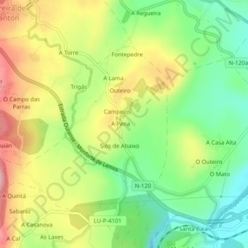
Name: Siós topographic map, elevation, terrain.
Location: Siós, Pantón, Tierra de Lemos, Lugo, Galicia, España (42.48528 -7.61631 42.50238 -7.60118)
Average elevation: 333 m
Minimum elevation: 260 m
Maximum elevation: 424 m
Other topographic maps
Click on a map to view its topography, its elevation and its terrain.
Lornís
España > Galicia > Tierra de Lemos > Pantón
Lornís, Frontón, Pantón, Tierra de Lemos, Lugo, Galicia, 32162, España
Average elevation: 422 m
Toiriz
España > Galicia > Tierra de Lemos > Pantón
Toiriz, Pantón, Tierra de Lemos, Lugo, Galicia, España
Average elevation: 521 m
Pantón
España > Galicia > Tierra de Lemos > Pantón
Pantón, Tierra de Lemos, Lugo, Galicia, España
Average elevation: 444 m