Geolocate

Sissinghurst topographic map

Click on the map to display elevation.

About this map
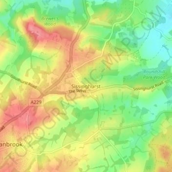
Name: Sissinghurst topographic map, elevation, terrain.

Location: Sissinghurst, Tunbridge Wells, Kent, England, TN17 2JF, United Kingdom (51.09006 0.54113 51.13006 0.58113)

Average elevation: 66 m

Minimum elevation: 29 m

Maximum elevation: 107 m

Other topographic maps

Click on a map to view its topography, its elevation and its terrain.

Benenden

United Kingdom > England > Kent > Tunbridge Wells > Benenden

Average elevation: 61 m

Speldhurst

United Kingdom > England > Kent > Tunbridge Wells

Average elevation: 89 m

Frittenden

United Kingdom > England > Kent > Tunbridge Wells

Average elevation: 34 m

Hawkhurst

United Kingdom > England > Kent > Tunbridge Wells

Average elevation: 67 m

Paddock Wood

United Kingdom > England > Kent > Tunbridge Wells

Average elevation: 33 m

Goudhurst

United Kingdom > England > Kent > Tunbridge Wells > Goudhurst

Average elevation: 76 m

Benenden

United Kingdom > England > Kent > Tunbridge Wells

Average elevation: 61 m

Pembury

United Kingdom > England > Kent > Tunbridge Wells

Average elevation: 99 m

Bidborough

United Kingdom > England > Kent > Tunbridge Wells

Average elevation: 71 m

Horsmonden

United Kingdom > England > Kent > Tunbridge Wells > Horsmonden

Average elevation: 51 m

Rusthall

United Kingdom > England > Kent > Tunbridge Wells > Rusthall

Average elevation: 100 m

Capel

United Kingdom > England > Kent > Tunbridge Wells

Average elevation: 47 m

Hurst Wood

United Kingdom > England > Kent > Tunbridge Wells > Rusthall

Average elevation: 101 m

Hawkhurst

United Kingdom > England > Kent > Tunbridge Wells

Average elevation: 67 m

Benenden

United Kingdom > England > Kent > Tunbridge Wells

Average elevation: 61 m

Goudhurst

United Kingdom > England > Kent > Tunbridge Wells

Average elevation: 76 m

Paddock Wood

United Kingdom > England > Kent > Tunbridge Wells > Whetsted

Average elevation: 33 m

Capel

United Kingdom > England > Kent > Tunbridge Wells

Average elevation: 47 m

Gear up for your next adventure:

📖Australian Bush Survival Books - Local knowledge on finding water and surviving the outback
📟Satellite Messengers - Two-way satellite communication to stay in touch beyond the cellular grid
🪑Portable Backpacking Chairs - A comfortable seat for studying maps at the end of the day
🦶Orthotic Hiking Insoles - Extra arch support for long-distance topographic treks
🔋Rechargeable Batteries - Eco-friendly power for high-drain GPS units and flashlights

As an Amazon Associate, this site earns from qualifying purchases at no extra cost to you.