
Make a donation
Gear up for your next adventure:
As an Amazon Associate, this site earns from qualifying purchases at no extra cost to you.
Beit Fajjar topographic map
Click on the map to display elevation.
Make a donation
Gear up for your next adventure:
As an Amazon Associate, this site earns from qualifying purchases at no extra cost to you.
Beit Fajjar
The site's high altitude was the highest point in the area and later the town expanded into other hills. During British rule in Palestine in the 1920s-1940s, Beit Fajjar was used as an observation point for the Bethlehem-Hebron area.
Make a donation
Gear up for your next adventure:
As an Amazon Associate, this site earns from qualifying purchases at no extra cost to you.
About this map
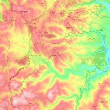
Name: Beit Fajjar topographic map, elevation, terrain.
Location: Beit Fajjar, Area B, West Bank, Palestinian Territory (31.58320 35.11387 31.66320 35.19387)
Average elevation: 878 m
Minimum elevation: 688 m
Maximum elevation: 1,013 m
Make a donation
Gear up for your next adventure:
As an Amazon Associate, this site earns from qualifying purchases at no extra cost to you.
Other topographic maps
Click on a map to view its topography, its elevation and its terrain.