
Khaet Preah Sihanouk topographic map
Interactive map
Click on the map to display elevation.
About this map
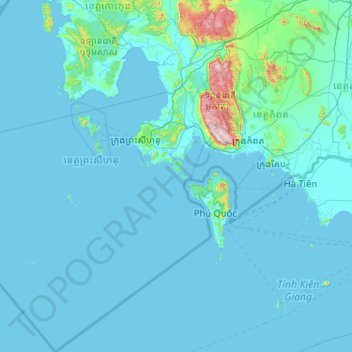
Name: Khaet Preah Sihanouk topographic map, elevation, terrain.
Location: Khaet Preah Sihanouk, Cambodia (9.45527 102.62956 11.43604 104.07725)
Average elevation: 33 m
Minimum elevation: -1 m
Maximum elevation: 1,062 m
Other topographic maps
Click on a map to view its topography, its elevation and its terrain.
Chong Koh - Ethnic Cham Fishing Village
Cambodia > Phnom Penh > Khan Chroy Changvar > Chong Koh - Ethnic Cham Fishing Village
Average elevation: 11 m
Sangkat Phsar Thmey Ti Muoy
Cambodia > Phnom Penh > Khan Daun Penh > Sangkat Phsar Thmey Ti Muoy
Average elevation: 13 m