
Cachi topographic map
Interactive map
Click on the map to display elevation.
About this map
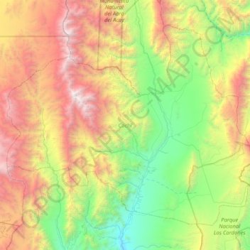
Name: Cachi topographic map, elevation, terrain.
Location: Cachi, Salta, Argentina (-25.29654 -66.59903 -24.73908 -65.83243)
Average elevation: 3,605 m
Minimum elevation: 2,087 m
Maximum elevation: 6,343 m
Other topographic maps
Click on a map to view its topography, its elevation and its terrain.
Cortaderas
Argentina > Salta > Cortaderas
Cortaderas, Municipio Isla de Cañas, Departamento Iruya, Salta, Argentina
Average elevation: 1,030 m