
Thank you for supporting this site ❤️
Make a donation
Make a donation
Gear up for your next adventure:
As an Amazon Associate, this site earns from qualifying purchases at no extra cost to you.
Roccamandolfi topographic map
Click on the map to display elevation.
Thank you for supporting this site ❤️
Make a donation
Make a donation
Gear up for your next adventure:
As an Amazon Associate, this site earns from qualifying purchases at no extra cost to you.
About this map
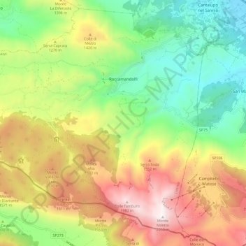
Name: Roccamandolfi topographic map, elevation, terrain.
Location: Roccamandolfi, Isernia, Molise, Italy (41.44317 14.27742 41.52143 14.39083)
Average elevation: 1,153 m
Minimum elevation: 518 m
Maximum elevation: 2,038 m
Thank you for supporting this site ❤️
Make a donation
Make a donation
Gear up for your next adventure:
🆘Personal Locator Beacons (PLB) - Satellite emergency beacons for life-saving help in areas with no mobile coverage
As an Amazon Associate, this site earns from qualifying purchases at no extra cost to you.
Other topographic maps
Click on a map to view its topography, its elevation and its terrain.
B o s c o d i M o n t e M i g l i o
Italy > Molise > Isernia > San Pietro Avellana
Average elevation: 1,008 m