
Make a donation
Gear up for your next adventure:
As an Amazon Associate, this site earns from qualifying purchases at no extra cost to you.
Kraków County topographic map
Click on the map to display elevation.
Make a donation
Gear up for your next adventure:
As an Amazon Associate, this site earns from qualifying purchases at no extra cost to you.
About this map
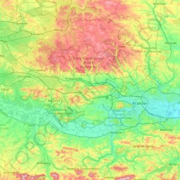
Name: Kraków County topographic map, elevation, terrain.
Location: Kraków County, Lesser Poland Voivodeship, Poland (49.88519 19.52039 50.31465 20.35376)
Average elevation: 307 m
Minimum elevation: 191 m
Maximum elevation: 559 m
Make a donation
Gear up for your next adventure:
As an Amazon Associate, this site earns from qualifying purchases at no extra cost to you.
Other topographic maps
Click on a map to view its topography, its elevation and its terrain.
Klein
Poland > Lesser Poland Voivodeship > Oświęcim County > Stawy Monowskie > Zalesie
Average elevation: 226 m
Svinica / Świnica
Poland > Lesser Poland Voivodeship > Tatra County > Brzegi
Average elevation: 1,857 m
Make a donation
Gear up for your next adventure:
As an Amazon Associate, this site earns from qualifying purchases at no extra cost to you.
Wielki Giewont
Poland > Lesser Poland Voivodeship > Tatra County > Zakopane
Average elevation: 1,478 m
Podzamcze
Poland > Lesser Poland Voivodeship > Kraków County > Korzkiew > Podzamcze
Average elevation: 321 m
Make a donation
Gear up for your next adventure:
As an Amazon Associate, this site earns from qualifying purchases at no extra cost to you.
Podkościele
Poland > Lesser Poland Voivodeship > Tarnów County > Wola Rzędzińska
Average elevation: 240 m
Morskie Oko
Poland > Lesser Poland Voivodeship > Tatra County > Brzegi
Morskie Oko at the foothill of Tatra Mountains in southern Poland which average 2,000 metres (6,600 ft) in elevation
Average elevation: 1,749 m
Make a donation
Gear up for your next adventure:
As an Amazon Associate, this site earns from qualifying purchases at no extra cost to you.
Tatry
Poland > Lesser Poland Voivodeship > Tatra County > Zakopane
The Tatras lie in the temperate zone of Central Europe. They are an important barrier to the movements of air masses. Their mountainous topography causes one of the most diverse climates in that region.
Average elevation: 1,647 m
Święty Krzyż
Poland > Lesser Poland Voivodeship > Nowy Sącz County > Królowa Polska > Góry
Average elevation: 463 m