Geolocate

Thrumster topographic map

Click on the map to display elevation.

About this map

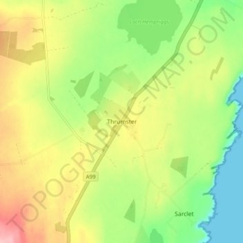
Name: Thrumster topographic map, elevation, terrain.

Location: Thrumster, Highland, Scotland, KW1 5TQ, United Kingdom (58.37050 -3.15570 58.41050 -3.11570)

Average elevation: 61 m

Minimum elevation: 0 m

Maximum elevation: 135 m

Other topographic maps

Click on a map to view its topography, its elevation and its terrain.

Loch Ness

United Kingdom > Scotland > Highland > Dores

Average elevation: 340 m

Strathnairn

United Kingdom > Scotland > Highland > Daviot

Average elevation: 268 m

Whitebridge

United Kingdom > Scotland > Highland

Average elevation: 223 m

Glen Coe

United Kingdom > Scotland > Highland > Glencoe

Average elevation: 414 m

Gear up for your next adventure:

🎒Dry Bags - Waterproof bags for outdoor gear
🧴Sunscreen SPF - Sun protection for outdoor activities
📸Action Cameras - Record your journey across interesting topographic features in 4K
🔭Compact Hiking Binoculars - Lightweight optics for scouting routes or birdwatching
🎒Ultralight Backpacks - Lightweight packs for long hikes

As an Amazon Associate, this site earns from qualifying purchases at no extra cost to you.