Geolocate

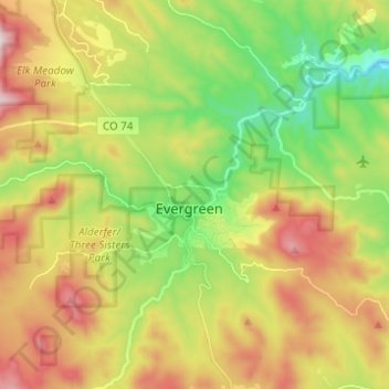
Evergreen topographic map

Click on the map to display elevation.

Evergreen

Evergreen sits at an elevation of 7,220 feet (2,200 m) in the Rocky Mountains, 19 miles west of Denver, Colorado. Its addresses are oriented according to the Street_system_of_Denver.

Wikipedia (CC-BY-SA 3.0)

About this map

Name: Evergreen topographic map, elevation, terrain.

Location: Evergreen, Jefferson County, Colorado, 80437, United States (39.58879 -105.37655 39.68362 -105.28097)

Average elevation: 2,309 m

Minimum elevation: 2,000 m

Maximum elevation: 2,713 m

Other topographic maps

Click on a map to view its topography, its elevation and its terrain.
Hiwan Hills

United States > Colorado > Jefferson County > Evergreen

Average elevation: 2,239 m

Herzman Mesa

United States > Colorado > Jefferson County > Evergreen

Average elevation: 2,349 m

Gear up for your next adventure:

👕UPF 50+ Sun Shirts - Essential protection against the harsh Australian sun during field work
📡Weather Radios - Emergency weather radios
🕶️Polarized Sunglasses - UV protection sunglasses for outdoors
🛌Sleeping Mats - Insulated mats for camping comfort
📖Australian Bush Survival Books - Local knowledge on finding water and surviving the outback

As an Amazon Associate, this site earns from qualifying purchases at no extra cost to you.