
Twin Towers (Jewell Peak) topographic map
Interactive map
Click on the map to display elevation.
About this map
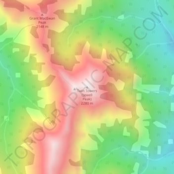
Name: Twin Towers (Jewell Peak) topographic map, elevation, terrain.
Average elevation: 1,852 m
Minimum elevation: 1,451 m
Maximum elevation: 2,299 m
Other topographic maps
Click on a map to view its topography, its elevation and its terrain.
Packenham Junior
Canada > Alberta > Kananaskis Improvement District
Packenham Junior, Kananaskis Improvement District, Alberta, Canada
Average elevation: 2,138 m
Mount Bolton
Canada > Alberta > Kananaskis Improvement District
Mount Bolton, Kananaskis Improvement District, Alberta, Canada
Average elevation: 2,266 m
Mount Glasgow
Canada > Alberta > Kananaskis Improvement District
Mount Glasgow, Kananaskis Improvement District, Alberta, Canada
Average elevation: 2,438 m
Mount Packenham
Canada > Alberta > Kananaskis Improvement District
Mount Packenham, Kananaskis Improvement District, Alberta, Canada
Average elevation: 2,444 m