
Largs topographic map
Click on the map to display elevation.
About this map
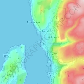
Name: Largs topographic map, elevation, terrain.
Location: Largs, North Ayrshire, Scotland, KA30 8LX, United Kingdom (55.75488 -4.90950 55.83488 -4.82950)
Average elevation: 110 m
Minimum elevation: -1 m
Maximum elevation: 449 m
Other topographic maps
Click on a map to view its topography, its elevation and its terrain.
Isle of Arran
United Kingdom > Scotland > North Ayrshire
The island has three endemic species of tree, the Arran whitebeams. These trees are the Scottish or Arran whitebeam (Sorbus arranensis), the bastard mountain ash or cut-leaved whitebeam (Sorbus pseudofennica) and the Catacol whitebeam (Sorbus pseudomeinichii). If rarity is measured by numbers alone they are…
Average elevation: 98 m