
Make a donation
Gear up for your next adventure:
As an Amazon Associate, this site earns from qualifying purchases at no extra cost to you.
Baker Lake topographic map
Click on the map to display elevation.
Make a donation
Gear up for your next adventure:
As an Amazon Associate, this site earns from qualifying purchases at no extra cost to you.
About this map
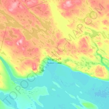
Name: Baker Lake topographic map, elevation, terrain.
Location: Baker Lake, Kivalliq Region, Nunavut, X0C 0A0, Canada (64.27396 -96.25879 64.39155 -95.71984)
Average elevation: 50 m
Minimum elevation: 0 m
Maximum elevation: 147 m
Make a donation
Gear up for your next adventure:
As an Amazon Associate, this site earns from qualifying purchases at no extra cost to you.
Other topographic maps
Click on a map to view its topography, its elevation and its terrain.
Make a donation
Gear up for your next adventure:
As an Amazon Associate, this site earns from qualifying purchases at no extra cost to you.
Make a donation
Gear up for your next adventure:
As an Amazon Associate, this site earns from qualifying purchases at no extra cost to you.
Yathkyed Lake
Canada > Nunavut > Kivalliq Region
It is part of the Hearne Domain, Western Churchill province of the Churchill craton, which is the northwest section of the Canadian Shield. According to the Atlas of Canada the geographical centre of the country lies just south of the lake at 62°24′N 096°28′W / 62.400°N 96.467°W / 62.400;…
Average elevation: 142 m
Make a donation
Gear up for your next adventure:
As an Amazon Associate, this site earns from qualifying purchases at no extra cost to you.