
Jungar Banner topographic map
Interactive map
Click on the map to display elevation.
About this map
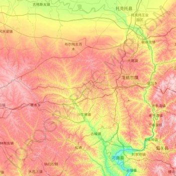
Name: Jungar Banner topographic map, elevation, terrain.
Location: Jungar Banner, Ordos City, Inner Mongolia, PRC (39.26648 110.10661 40.32719 111.45685)
Average elevation: 1,177 m
Minimum elevation: 842 m
Maximum elevation: 1,577 m
Other topographic maps
Click on a map to view its topography, its elevation and its terrain.
Taiping Ling
Taiping Ling, Arxan City, Hinggan League, Inner Mongolia, PRC
Average elevation: 1,511 m
Xilinhot
PRC > Inner Mongolia > Xilinhot
Xilinhot, Xilinhot City, Xilingol League, Inner Mongolia, PRC
Average elevation: 1,067 m
敖包疙瘩
PRC > Inner Mongolia > Alxa Left Banner
敖包疙瘩, Alxa Left Banner, Alxa League, Inner Mongolia, PRC
Average elevation: 3,154 m
Greater Khingan Mountain Range
Greater Khingan Mountain Range, Zalantun City, Hulunbuir, Inner Mongolia, PRC
Average elevation: 1,514 m