
Make a donation
Gear up for your next adventure:
As an Amazon Associate, this site earns from qualifying purchases at no extra cost to you.
Meilegem topographic map
Click on the map to display elevation.
Make a donation
Gear up for your next adventure:
As an Amazon Associate, this site earns from qualifying purchases at no extra cost to you.
Meilegem
Meilegem ligt in Zandlemig Vlaanderen op een hoogte van 12-48 meter. Het hoogste punt is de Meilegemberg van waar men een weids uitzicht heeft. Ten westen van Meilegem stroomt de Schelde. Aan de oude Scheldearm vindt men het natuurgebied Kaaimeersen met het bezoekerscentrum De Kaaihoeve.
Make a donation
Gear up for your next adventure:
As an Amazon Associate, this site earns from qualifying purchases at no extra cost to you.
About this map
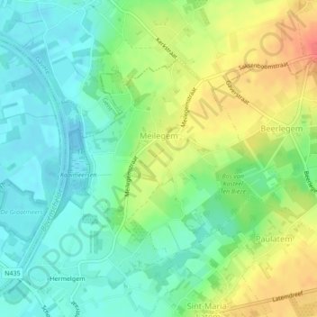
Name: Meilegem topographic map, elevation, terrain.
Location: Meilegem, Zwalm, Oudenaarde, Oost-Vlaanderen, België (50.89469 3.68557 50.91172 3.71230)
Average elevation: 26 m
Minimum elevation: 4 m
Maximum elevation: 61 m
Make a donation
Gear up for your next adventure:
As an Amazon Associate, this site earns from qualifying purchases at no extra cost to you.
Other topographic maps
Click on a map to view its topography, its elevation and its terrain.
Make a donation
Gear up for your next adventure:
As an Amazon Associate, this site earns from qualifying purchases at no extra cost to you.