
Hollyford River topographic map
Interactive map
Click on the map to display elevation.
About this map
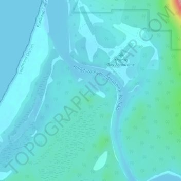
Name: Hollyford River topographic map, elevation, terrain.
Average elevation: 14 m
Minimum elevation: -3 m
Maximum elevation: 138 m
Other topographic maps
Click on a map to view its topography, its elevation and its terrain.
Milford Sound
New Zealand > Southland > Southland District > Fiordland Community
Milford Sound, Fiordland Community, Southland District, Southland, New Zealand
Average elevation: 655 m
Mount Elliot
New Zealand > Southland > Southland District > Fiordland Community
Mount Elliot, Fiordland Community, Southland District, Southland, New Zealand
Average elevation: 1,110 m
Lake Alabaster
New Zealand > Southland > Southland District > Fiordland Community
Lake Alabaster, Fiordland Community, Southland District, Southland, New Zealand
Average elevation: 605 m
Manapouri
New Zealand > Southland > Southland District > Fiordland Community
Manapouri, Fiordland Community, Southland District, Southland, 7969, New Zealand
Average elevation: 213 m
Milford Sound
New Zealand > Southland > Southland District > Fiordland Community > Milford Sound
Milford Sound, Fiordland Community, Southland District, Southland, New Zealand
Average elevation: 304 m
Puhipuhi takiwai / Mount Pembroke
New Zealand > Southland > Southland District > Fiordland Community
Puhipuhi takiwai / Mount Pembroke, Fiordland Community, Southland District, Southland, New Zealand
Average elevation: 1,262 m