
Khan Mean Chey topographic map
Interactive map
Click on the map to display elevation.
About this map
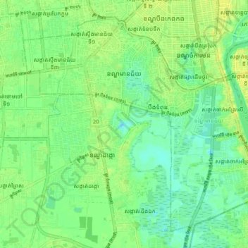
Name: Khan Mean Chey topographic map, elevation, terrain.
Location: Khan Mean Chey, Phnom Penh, Cambodia (11.48236 104.86598 11.54998 104.94593)
Average elevation: 10 m
Minimum elevation: -1 m
Maximum elevation: 20 m
Other topographic maps
Click on a map to view its topography, its elevation and its terrain.
Phnom Penh
Cambodia > Phnom Penh > Khan Daun Penh
Phnom Penh, Khan Daun Penh, Phnom Penh, 120203, Cambodia
Average elevation: 10 m
Boeung Trabek
Cambodia > Phnom Penh > Khan Chamkar Mon
Boeung Trabek, Khan Chamkar Mon, Phnom Penh, 120112, Cambodia
Average elevation: 11 m
Chong Koh - Ethnic Cham Fishing Village
Cambodia > Phnom Penh > Khan Chroy Changvar > Chong Koh - Ethnic Cham Fishing Village
Chong Koh - Ethnic Cham Fishing Village, Khan Chroy Changvar, Phnom Penh, 12206, Cambodia
Average elevation: 11 m
Khan Mean Chey
Cambodia > Phnom Penh > Khan Mean Chey
Khan Mean Chey, Phnom Penh, 12351, Cambodia
Average elevation: 11 m