
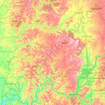
Hoosier National Forest topographic map
Interactive map
Click on the map to display elevation.
About this map
Name: Hoosier National Forest topographic map, elevation, terrain.
Location: Hoosier National Forest, Indiana, United States of America (37.87503 -86.85119 39.10843 -86.07997)
Average elevation: 192 m
Minimum elevation: 110 m
Maximum elevation: 310 m
Other topographic maps
Click on a map to view its topography, its elevation and its terrain.
Turkey Run State Park
United States of America > Indiana > Cincinnati
Turkey Run State Park, Cox Ford Road, Cincinnati, Parke County, Indiana, 47859, United States of America
Average elevation: 197 m
Maumee River
United States of America > Indiana
Maumee River, Allen County, Indiana, 46774, United States of America
Average elevation: 233 m
Duck Pond
United States of America > Indiana > Muncie
Duck Pond, North McKinley Avenue, Muncie, Delaware County, Indiana, 47303, United States of America
Average elevation: 289 m
Winona Lake
United States of America > Indiana > Winona Lake
Winona Lake, Kosciusko County, Indiana, 46590, United States of America
Average elevation: 256 m
Saint Anthony
United States of America > Indiana > Saint Anthony
Saint Anthony, Dubois County, Indiana, 47575, United States of America
Average elevation: 170 m
Shoals
United States of America > Indiana > Shoals
Shoals, Martin County, Indiana, 47581, United States of America
Average elevation: 152 m
Rochester
United States of America > Indiana > Rochester
Rochester, Fulton County, Indiana, United States of America
Average elevation: 240 m
Covington Dells
United States of America > Indiana > Fort Wayne > Covington Dells
Covington Dells, Fort Wayne, Allen County, Indiana, 46804, United States of America
Average elevation: 252 m
River Ridge
United States of America > Indiana > River Ridge
River Ridge, Clark County, Indiana, United States of America
Average elevation: 157 m
Westmoor
United States of America > Indiana > Fort Wayne > Westmoor
Westmoor, Fort Wayne, Allen County, Indiana, 46804, United States of America
Average elevation: 245 m
West Franklin
United States of America > Indiana > West Franklin
West Franklin, Posey County, Indiana, United States of America
Average elevation: 116 m
Center
United States of America > Indiana > Greene > Center
Center, Greene, Jay County, Indiana, United States of America
Average elevation: 271 m