
Miquelon-Langlade topographic map
Interactive map
Click on the map to display elevation.
About this map
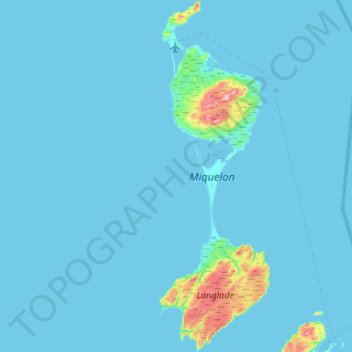
Name: Miquelon-Langlade topographic map, elevation, terrain.
Location: Miquelon-Langlade, São Pedro e Miquelão, 97500, França (46.78277 -56.40588 47.14426 -56.23760)
Average elevation: 10 m
Minimum elevation: -1 m
Maximum elevation: 230 m
Other topographic maps
Click on a map to view its topography, its elevation and its terrain.
São Pedro e Miquelão
São Pedro e Miquelão, França
Average elevation: 11 m