
Schwarmstedt topographic map
Interactive map
Click on the map to display elevation.
About this map
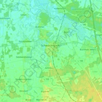
Name: Schwarmstedt topographic map, elevation, terrain.
Average elevation: 29 m
Minimum elevation: 22 m
Maximum elevation: 40 m
Other topographic maps
Click on a map to view its topography, its elevation and its terrain.
Drögenheide
Germany > Lower Saxony > Heidekreis > Soltau > Friedrichseck
Drögenheide, Friedrichseck, Soltau, Heidekreis, Lower Saxony, 29614, Germany
Average elevation: 73 m