
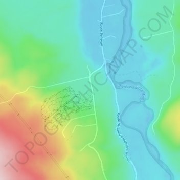
Mont-Bellevue topographic map
Interactive map
Click on the map to display elevation.
About this map
Name: Mont-Bellevue topographic map, elevation, terrain.
Average elevation: 86 m
Minimum elevation: -3 m
Maximum elevation: 304 m
Other topographic maps
Click on a map to view its topography, its elevation and its terrain.
Ruisseau-Castor
Canada > Québec > La Haute-Gaspésie > Sainte-Anne-des-Monts
Ruisseau-Castor, Sainte-Anne-des-Monts, La Haute-Gaspésie, Gaspésie–Îles-de-la-Madeleine, Québec, Canada
Average elevation: 99 m
Tourelle
Canada > Québec > La Haute-Gaspésie > Sainte-Anne-des-Monts
Tourelle, Sainte-Anne-des-Monts, La Haute-Gaspésie, Gaspésie–Îles-de-la-Madeleine, Québec, Canada
Average elevation: 48 m