
Make a donation
Gear up for your next adventure:
As an Amazon Associate, this site earns from qualifying purchases at no extra cost to you.
Genooi topographic map
Click on the map to display elevation.
Make a donation
Gear up for your next adventure:
As an Amazon Associate, this site earns from qualifying purchases at no extra cost to you.
About this map
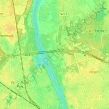
Name: Genooi topographic map, elevation, terrain.
Location: Genooi, Venlo, Limburg, Nederland, 5914 HE, Nederland (51.37462 6.14088 51.41462 6.18088)
Average elevation: 22 m
Minimum elevation: 9 m
Maximum elevation: 30 m
Make a donation
Gear up for your next adventure:
As an Amazon Associate, this site earns from qualifying purchases at no extra cost to you.
Other topographic maps
Click on a map to view its topography, its elevation and its terrain.
Hout-Blerick
Nederland > Limburg > Venlo > Hout-Blerick
Hout-Blerick ligt op de linkeroever van de Maas op een hoogte van ongeveer 19 meter. Het wordt naar het noorden en aan de oostzijde omgeven door verstedelijkt gebied, zoals nieuwbouwwijken en de kom van Blerick. In het zuiden vindt men veel glastuinbouw, met in het zuidwesten naaldbos en recreatieterrein.…
Average elevation: 22 m