Geolocate

Wacton topographic map

Click on the map to display elevation.

About this map

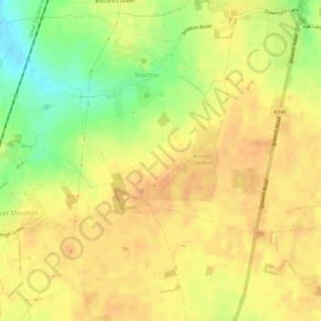
Name: Wacton topographic map, elevation, terrain.

Location: Wacton, South Norfolk, Norfolk, England, United Kingdom (52.45485 1.18491 52.48610 1.22712)

Average elevation: 53 m

Minimum elevation: 30 m

Maximum elevation: 62 m

Gear up for your next adventure:

🦘Outback Survival Gear - Essential gear for Australian outback
🎨Portable Watercolor Kits - Paint the landscapes and topographic views you discover
🔥Windproof Plasma Lighters - USB rechargeable lighters that work in high-altitude winds
🖼️Scratch-off Australia Map - Track the regions and peaks you have explored geographically
🚴Bike GPS - GPS devices for cycling

As an Amazon Associate, this site earns from qualifying purchases at no extra cost to you.