
Make a donation
Gear up for your next adventure:
As an Amazon Associate, this site earns from qualifying purchases at no extra cost to you.
Richland topographic map
Click on the map to display elevation.
Make a donation
Gear up for your next adventure:
As an Amazon Associate, this site earns from qualifying purchases at no extra cost to you.
About this map
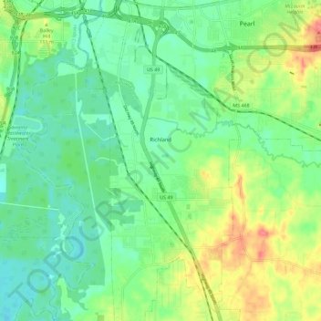
Name: Richland topographic map, elevation, terrain.
Location: Richland, Rankin County, Mississippi, 39218, United States (32.18468 -90.18757 32.28046 -90.13036)
Average elevation: 90 m
Minimum elevation: 66 m
Maximum elevation: 135 m
Make a donation
Gear up for your next adventure:
As an Amazon Associate, this site earns from qualifying purchases at no extra cost to you.
Other topographic maps
Click on a map to view its topography, its elevation and its terrain.
Make a donation
Gear up for your next adventure:
As an Amazon Associate, this site earns from qualifying purchases at no extra cost to you.
Make a donation
Gear up for your next adventure:
As an Amazon Associate, this site earns from qualifying purchases at no extra cost to you.
Hickory Glen
United States > Mississippi > Rankin County > Pearl > Hickory Glen
Average elevation: 92 m