Geolocate

Buraydah topographic map

Click on the map to display elevation.

About this map
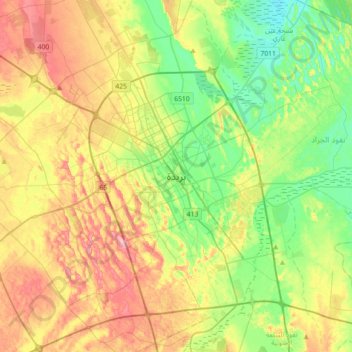
Name: Buraydah topographic map, elevation, terrain.

Location: Buraydah, Al-Qassim Province, 52354, Saudi Arabia (26.17167 43.81167 26.49167 44.13167)

Average elevation: 628 m

Minimum elevation: 578 m

Maximum elevation: 699 m

Other topographic maps

Click on a map to view its topography, its elevation and its terrain.

Uyun Al Jiwa

Saudi Arabia > Al-Qassim Province

Average elevation: 754 m

Unaizah

Saudi Arabia > Al-Qassim Province > Unayzah

Average elevation: 660 m

Uyun Al Jiwa

Saudi Arabia > Al-Qassim Province

Average elevation: 754 m

Unaizah

Saudi Arabia > Al-Qassim Province

Average elevation: 660 m

Al Bukayriyah

Saudi Arabia > Al-Qassim Province

Average elevation: 685 m

Al Asyah

Saudi Arabia > Al-Qassim Province

Average elevation: 577 m

Al Bandariyah

Saudi Arabia > Al-Qassim Province

Average elevation: 568 m

Al Midhnab

Saudi Arabia > Al-Qassim Province

Average elevation: 710 m

Al Midhnab

Saudi Arabia > Al-Qassim Province

Average elevation: 710 m

Ar Rass

Saudi Arabia > Al-Qassim Province

Average elevation: 766 m

Gear up for your next adventure:

💡Collapsible Camping Lanterns - Illuminate your base camp or tent for map studying at night
🏃Compression Recovery Socks - Reduce leg fatigue after heavy days of elevation gain
🦯Adjustable Trekking Poles - Reduce impact on knees when descending steep topographic ridges
🪢550 Survival Paracord - Versatile cordage for gear repair and emergency lashing
🧺Fast-Dry Microfiber Towels - Large towels that pack down to the size of an orange

As an Amazon Associate, this site earns from qualifying purchases at no extra cost to you.