
San Juan topographic map
Interactive map
Click on the map to display elevation.
About this map
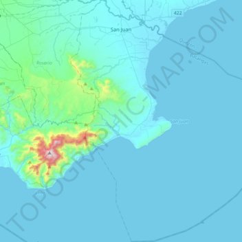
Name: San Juan topographic map, elevation, terrain.
Location: San Juan, Batangas, Calabarzon, 4226, Philippines (13.52156 121.32191 13.86739 121.61033)
Average elevation: 60 m
Minimum elevation: -3 m
Maximum elevation: 969 m
Other topographic maps
Click on a map to view its topography, its elevation and its terrain.
Taal Volcano
Philippines > Batangas > San Nicolas
Volcano Island sank from 1 to 3 m (3 to 10 ft) as a result of the eruption. It was also found that the southern shore of Lake Taal sank in elevation from the eruption. No evidences of lava could be discovered anywhere, nor have geologists been able to trace any visible records of a lava flow having occurred at…
Average elevation: 88 m