
Thank you for supporting this site ❤️
Make a donation
Make a donation
Gear up for your next adventure:
As an Amazon Associate, this site earns from qualifying purchases at no extra cost to you.
Cinigiano topographic map
Click on the map to display elevation.
Thank you for supporting this site ❤️
Make a donation
Make a donation
Gear up for your next adventure:
🆘Personal Locator Beacons (PLB) - Satellite emergency beacons for life-saving help in areas with no mobile coverage
As an Amazon Associate, this site earns from qualifying purchases at no extra cost to you.
About this map
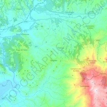
Name: Cinigiano topographic map, elevation, terrain.
Location: Cinigiano, Grosseto, Tuscany, 58044, Italy (42.83153 11.27127 42.97127 11.50494)
Average elevation: 268 m
Minimum elevation: 27 m
Maximum elevation: 1,154 m
Thank you for supporting this site ❤️
Make a donation
Make a donation
Gear up for your next adventure:
🧭Military Style Lensatic Compass - Durable sighting compasses for advanced land navigation and surveying
As an Amazon Associate, this site earns from qualifying purchases at no extra cost to you.
Other topographic maps
Click on a map to view its topography, its elevation and its terrain.