
Make a donation
Gear up for your next adventure:
As an Amazon Associate, this site earns from qualifying purchases at no extra cost to you.
Sorocaba topographic map
Click on the map to display elevation.
Make a donation
Gear up for your next adventure:
As an Amazon Associate, this site earns from qualifying purchases at no extra cost to you.
Sorocaba
The terrain is classified as a wavy strands and characterized by local ridges, with an average altitude of 632 meters above the sea level. The highest altitude is 1028 meters, in the Serra de Sao Francisco. The lower altitude is 539 meters, in the valley of the Sorocaba River. Sorocaba is located on the edge of the Peripheral Depression of São Paulo state, in the Appalachian Fall Line, as defined by Professor Aziz Ab'Saber. This configuration is due to the fact Sorocaba lies at the boundary between the Atlantic Plateau, which covers the area of crystalline rocks, with higher relief and the rocks of the Parana Sedimentary Basin and gently rolling topography with lower altitudes. The Sorocaba River and its hydrographic basin are responsible for the relief dissection.
Make a donation
Gear up for your next adventure:
As an Amazon Associate, this site earns from qualifying purchases at no extra cost to you.
About this map
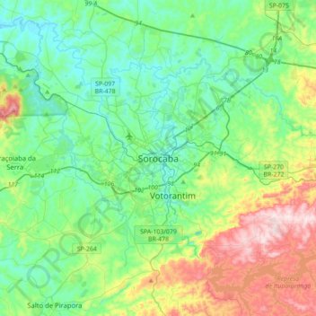
Name: Sorocaba topographic map, elevation, terrain.
Average elevation: 662 m
Minimum elevation: 528 m
Maximum elevation: 1,033 m
Make a donation
Gear up for your next adventure:
As an Amazon Associate, this site earns from qualifying purchases at no extra cost to you.