
Veľký Biel topographic map
Interactive map
Click on the map to display elevation.
About this map
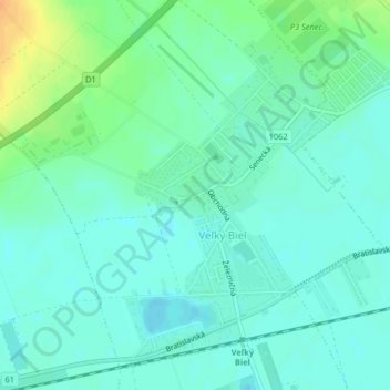
Name: Veľký Biel topographic map, elevation, terrain.
Average elevation: 130 m
Minimum elevation: 121 m
Maximum elevation: 153 m
The municipality lies at an altitude of 131 metres and covers an area of 10.161 km². It has a population of 2303 people.
Other topographic maps
Click on a map to view its topography, its elevation and its terrain.
Veľkobielske jazero "Šutrovka"
Slovakia > Region of Bratislava > District of Senec > Veľký Biel
Veľkobielske jazero "Šutrovka", Veľký Biel, District of Senec, Region of Bratislava, Slovakia
Average elevation: 127 m
Bernolákovo
Slovakia > Region of Bratislava > District of Senec > Bernolákovo
Bernolákovo, District of Senec, Region of Bratislava, 900 27, Slovakia
Average elevation: 133 m
Senec
Slovakia > Region of Bratislava > District of Senec
Senec, District of Senec, Region of Bratislava, Slovakia
Average elevation: 134 m
Dunajská Lužná
Slovakia > Region of Bratislava > District of Senec
Dunajská Lužná, District of Senec, Region of Bratislava, Slovakia
Average elevation: 129 m