
Make a donation
Gear up for your next adventure:
As an Amazon Associate, this site earns from qualifying purchases at no extra cost to you.
Cunco topographic map
Click on the map to display elevation.
Make a donation
Gear up for your next adventure:
As an Amazon Associate, this site earns from qualifying purchases at no extra cost to you.
About this map
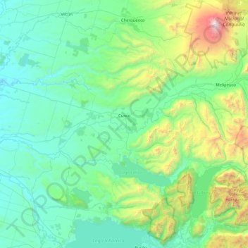
Name: Cunco topographic map, elevation, terrain.
Location: Cunco, Provincia de Cautín, Araucania Region, Chile (-39.18582 -72.35814 -38.72556 -71.53417)
Average elevation: 610 m
Minimum elevation: 109 m
Maximum elevation: 3,081 m
Make a donation
Gear up for your next adventure:
As an Amazon Associate, this site earns from qualifying purchases at no extra cost to you.
Other topographic maps
Click on a map to view its topography, its elevation and its terrain.
Make a donation
Gear up for your next adventure:
As an Amazon Associate, this site earns from qualifying purchases at no extra cost to you.
Volcán Llaima
Chile > Araucanía Region > Provincia de Cautín > Vilcún
The average elevation of the terrain around Llaima is about 740 m asl.
Average elevation: 2,519 m
Make a donation
Gear up for your next adventure:
As an Amazon Associate, this site earns from qualifying purchases at no extra cost to you.