
Make a donation
Gear up for your next adventure:
As an Amazon Associate, this site earns from qualifying purchases at no extra cost to you.
Marienberg topographic map
Click on the map to display elevation.
Make a donation
Gear up for your next adventure:
As an Amazon Associate, this site earns from qualifying purchases at no extra cost to you.
Marienberg
The town is situated on a plateau north of the Ore Mountains ridge, at an elevation between 460 and 891 metres above sea level. It is approximately 31 kilometres south of Chemnitz, to which it is connected via the Flöha Valley Railway.
Make a donation
Gear up for your next adventure:
As an Amazon Associate, this site earns from qualifying purchases at no extra cost to you.
About this map
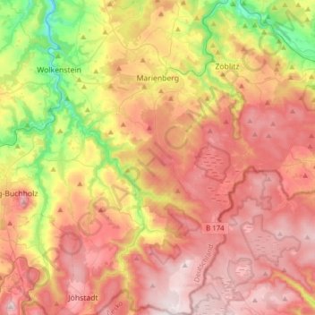
Name: Marienberg topographic map, elevation, terrain.
Location: Marienberg, Erzgebirgskreis, Saxony, 09496, Germany (50.50289 13.11699 50.69897 13.32772)
Average elevation: 657 m
Minimum elevation: 356 m
Maximum elevation: 901 m
Make a donation
Gear up for your next adventure:
As an Amazon Associate, this site earns from qualifying purchases at no extra cost to you.
Other topographic maps
Click on a map to view its topography, its elevation and its terrain.
Markersbach
Germany > Saxony > Erzgebirgskreis
In 1889, Markersbach was connected to the railway line from Schwarzenberg to Annaberg, which was closed to passenger transport on 27 September 1997. The station lay in Mittweida’s municipal area and the platform signs read Mittweida-Markersbach. To overcome the great elevation differential, the railway's…
Average elevation: 600 m
Make a donation
Gear up for your next adventure:
As an Amazon Associate, this site earns from qualifying purchases at no extra cost to you.