Geolocate

Nasugbu topographic map

Click on the map to display elevation.

About this map

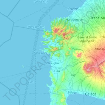
Name: Nasugbu topographic map, elevation, terrain.

Location: Nasugbu, Batangas, Calabarzon, 4231, Philippines (13.99841 120.34558 14.24446 120.84513)

Average elevation: 71 m

Minimum elevation: -2 m

Maximum elevation: 759 m

Other topographic maps

Click on a map to view its topography, its elevation and its terrain.

Maruclap

Philippines > Batangas > Batangas City

Average elevation: 224 m

San Carlos

Philippines > Batangas > Rosario

Average elevation: 128 m

Lumaniag

Philippines > Batangas > Lian

Average elevation: 37 m

Dela Paz Pulot Aplaya

Philippines > Batangas

Average elevation: 95 m

Sabang

Philippines > Batangas > Tuy > Sabang

Average elevation: 53 m

Latag

Philippines > Batangas > Nasugbu > Latag

Average elevation: 132 m

District I

Philippines > Batangas

Average elevation: 329 m

Gear up for your next adventure:

🎒Dry Bags - Waterproof bags for outdoor gear
🚁Camera Drones with GPS - Capture aerial views of the landscape to compare with topo maps
🪫Rechargeable Headlamps - USB rechargeable headlamps
🔥Ferrocerium Rod Fire Starters - Reliable fire lighting in wet or windy conditions without matches
🏕️Camping Gear - Essential camping equipment

As an Amazon Associate, this site earns from qualifying purchases at no extra cost to you.