
Chelsham topographic map
Click on the map to display elevation.
About this map
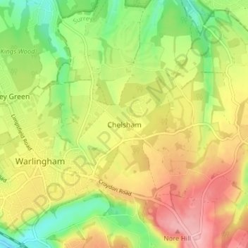
Name: Chelsham topographic map, elevation, terrain.
Average elevation: 176 m
Minimum elevation: 106 m
Maximum elevation: 248 m
Other topographic maps
Click on a map to view its topography, its elevation and its terrain.
Warlingham
United Kingdom > England > Surrey > Chelsham
Elevations vary from 110m AOD at Woldingham Road, at the southernmost point of the parish, with a gentle increase in height through the village along the main road heading to the southeast, to the highest elevation (199.6m) at Limpsfield Road.
Average elevation: 163 m