
Lac Sacacomie topographic map
Interactive map
Click on the map to display elevation.
About this map
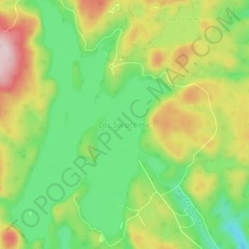
Name: Lac Sacacomie topographic map, elevation, terrain.
Average elevation: 316 m
Minimum elevation: 204 m
Maximum elevation: 490 m
Other topographic maps
Click on a map to view its topography, its elevation and its terrain.
Chute à Lessard
Canada > Québec > Saint-Alexis-des-Monts
Chute à Lessard, Rang de la Chute a Lessard, Saint-Alexis-des-Monts, Maskinongé (MRC), Mauricie, Québec, J0K 1V0, Canada
Average elevation: 190 m
Lac Pelletier
Canada > Québec > Saint-Alexis-des-Monts
Lac Pelletier, Saint-Alexis-des-Monts, Maskinongé (MRC), Mauricie, Québec, Canada
Average elevation: 308 m