
Oakley topographic map
Interactive map
Click on the map to display elevation.
About this map
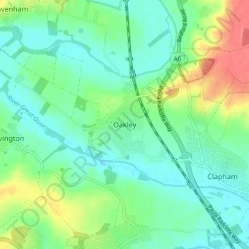
Name: Oakley topographic map, elevation, terrain.
Average elevation: 48 m
Minimum elevation: 29 m
Maximum elevation: 90 m
Other topographic maps
Click on a map to view its topography, its elevation and its terrain.
River Great Ouse
United Kingdom > England > Oakley
River Great Ouse, Church Lane, Bromham, Oakley, Bedford, East of England, England, MK43 7RU, United Kingdom
Average elevation: 46 m