
Make a donation
Gear up for your next adventure:
As an Amazon Associate, this site earns from qualifying purchases at no extra cost to you.
Roermond topographic map
Click on the map to display elevation.
Make a donation
Gear up for your next adventure:
As an Amazon Associate, this site earns from qualifying purchases at no extra cost to you.
Roermond
Roermond werd in 1130 Ruregemunde genoemd. Het eerste woorddeel verwijst naar de rivier Roer, die genoemd zou zijn naar een Keltisch-Germaanse watergodin "Rura". Het tweede woorddeel lijkt te verwijzen naar de "monding" van de Roer, maar dit is minder waarschijnlijk aangezien de Roer en de Maas tot ±1340 aan de Weerd samenkwamen. Daarna brak de Maas ter hoogte van Beegden door haar oevers en werd de Hambeek, 1 km ten zuidwesten van Roermond, een tweede uitmonding van de Roer in de Maas, waardoor aldus een deltamonding ontstond. Andere verklaringen, nl. dat "monde" zou verwijzen naar een (eventueel versterkte) heuvel, een brug of een Frankische burcht zijn evenmin zeker.
Make a donation
Gear up for your next adventure:
As an Amazon Associate, this site earns from qualifying purchases at no extra cost to you.
About this map
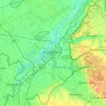
Name: Roermond topographic map, elevation, terrain.
Location: Roermond, Limburg, Nederland, 6041HT, Nederland (51.03017 5.83141 51.35017 6.15141)
Average elevation: 39 m
Minimum elevation: 11 m
Maximum elevation: 150 m
Make a donation
Gear up for your next adventure:
As an Amazon Associate, this site earns from qualifying purchases at no extra cost to you.
Other topographic maps
Click on a map to view its topography, its elevation and its terrain.