
Make a donation
Gear up for your next adventure:
As an Amazon Associate, this site earns from qualifying purchases at no extra cost to you.
Grächen topographic map
Click on the map to display elevation.
Make a donation
Gear up for your next adventure:
As an Amazon Associate, this site earns from qualifying purchases at no extra cost to you.
Grächen
The village is situated at an altitude of 1,620 meters (5,310 ft) on a terrace above St. Niklaus in the Mattertal, north of the Mischabel range (and Dom).
Make a donation
Gear up for your next adventure:
As an Amazon Associate, this site earns from qualifying purchases at no extra cost to you.
About this map
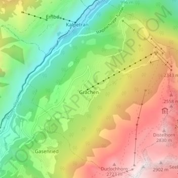
Name: Grächen topographic map, elevation, terrain.
Location: Grächen, Visp, Wallis, 3925, Switzerland (46.17343 7.81783 46.22015 7.87375)
Average elevation: 1,757 m
Minimum elevation: 834 m
Maximum elevation: 3,017 m
Make a donation
Gear up for your next adventure:
As an Amazon Associate, this site earns from qualifying purchases at no extra cost to you.