
L'Olmet topographic map
Interactive map
Click on the map to display elevation.
About this map
Name: L'Olmet topographic map, elevation, terrain.
Average elevation: 433 m
Minimum elevation: 328 m
Maximum elevation: 499 m
Other topographic maps
Click on a map to view its topography, its elevation and its terrain.
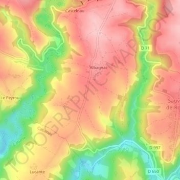
Albagnac
France > Occitanie > Sauveterre-de-Rouergue > Albagnac
Albagnac, Sauveterre-de-Rouergue, Villefranche-de-Rouergue, Aveyron, Occitanie, France métropolitaine, 12800, France
Average elevation: 445 m