Geolocate

Kisolon topographic map

Click on the map to display elevation.

About this map

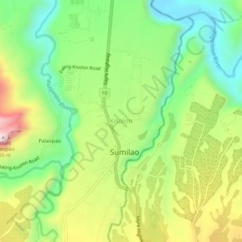
Name: Kisolon topographic map, elevation, terrain.

Location: Kisolon, Sumilao, Bukidnon, Northern Mindanao, Philippines (8.31401 124.95912 8.35401 124.99912)

Average elevation: 507 m

Minimum elevation: 306 m

Maximum elevation: 804 m

Other topographic maps

Click on a map to view its topography, its elevation and its terrain.

Tagoloan River

Philippines > Bukidnon > Sumilao > Damay

Average elevation: 369 m

Kulaman River

Philippines > Bukidnon > Sumilao > San Vicente

Average elevation: 402 m

Gear up for your next adventure:

🔪Camping Knives - Multi-purpose outdoor knives
🧦Hiking Socks - Comfortable socks for long hikes
🧊Insulated Cooler Bags - Keep food fresh for day trips to remote geographic sites
🔦Headlamps - Hands-free lighting for hiking
🎒Tactical Waist Packs - Quick access to your compass, phone, and snacks while walking

As an Amazon Associate, this site earns from qualifying purchases at no extra cost to you.