
Culiacán topographic map
Interactive map
Click on the map to display elevation.
About this map
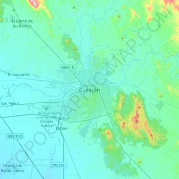
Name: Culiacán topographic map, elevation, terrain.
Location: Culiacán, Sinaloa, 80200, México (24.63790 -107.55340 24.95790 -107.23340)
Average elevation: 85 m
Minimum elevation: 6 m
Maximum elevation: 764 m
Se ubica en la región centro del Estado de Sinaloa, formando parte del noroeste de México. Le corresponden las coordenadas: 24°48'15" N (latitud norte) y 107°25'52" O (longitud oeste), con una altitud de 54 metros sobre el nivel del mar.
Other topographic maps
Click on a map to view its topography, its elevation and its terrain.