
Valenzuela topographic map
Click on the map to display elevation.
Valenzuela
The highest elevation point is 38 metres (125 ft) above sea level. Having a surface gradient of 0.55% and a gentle slope, hilly landscape is located in the industrial section of the city in Canumay. The average elevation point is 2 metres (6.6 ft) above sea level.
About this map
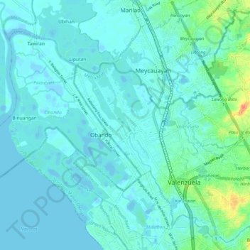
Name: Valenzuela topographic map, elevation, terrain.
Location: Valenzuela, Metro Manila, Philippines (14.66875 120.92579 14.75839 121.02459)
Average elevation: 6 m
Minimum elevation: -4 m
Maximum elevation: 40 m
Other topographic maps
Click on a map to view its topography, its elevation and its terrain.