
Geel topographic map
Interactive map
Click on the map to display elevation.
About this map
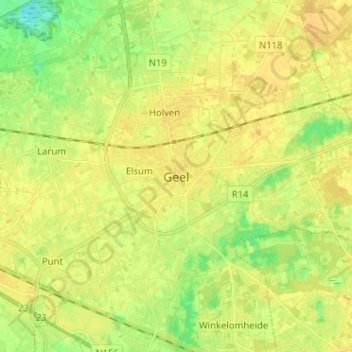
Name: Geel topographic map, elevation, terrain.
Location: Geel, Turnhout, Antwerpen, Vlaanderen, 2440, België (51.12108 4.95032 51.20108 5.03032)
Average elevation: 20 m
Minimum elevation: 5 m
Maximum elevation: 28 m
Other topographic maps
Click on a map to view its topography, its elevation and its terrain.
Neerhelst - De Botten
België > Antwerpen > Turnhout > Geel
Neerhelst - De Botten, Gebeunt, Geel, Turnhout, Antwerpen, Vlaanderen, 2440, België
Average elevation: 15 m
Winkelomheide
België > Antwerpen > Turnhout > Geel
Winkelomheide, Geel, Turnhout, Antwerpen, Vlaanderen, 2430, België
Average elevation: 19 m