
Make a donation
Gear up for your next adventure:
As an Amazon Associate, this site earns from qualifying purchases at no extra cost to you.
Greater Tubatse Local Municipality topographic map
Click on the map to display elevation.
Make a donation
Gear up for your next adventure:
As an Amazon Associate, this site earns from qualifying purchases at no extra cost to you.
About this map
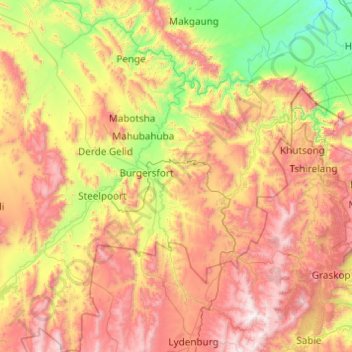
Name: Greater Tubatse Local Municipality topographic map, elevation, terrain.
Average elevation: 1,140 m
Minimum elevation: 397 m
Maximum elevation: 2,235 m
Make a donation
Gear up for your next adventure:
As an Amazon Associate, this site earns from qualifying purchases at no extra cost to you.
Other topographic maps
Click on a map to view its topography, its elevation and its terrain.
Ga-Masemola
South Africa > Limpopo > Sekhukhune District Municipality > Makhuduthamaga Local Municipality
Average elevation: 911 m
Burgersfort
South Africa > Limpopo > Sekhukhune District Municipality > Greater Tubatse Local Municipality
Average elevation: 810 m
Groblersdal
South Africa > Limpopo > Sekhukhune District Municipality > Elias Motsoaledi Local Municipality
Average elevation: 939 m
Molepo
South Africa > Limpopo > Sekhukhune District Municipality > Greater Tubatse Local Municipality
Average elevation: 872 m
Make a donation
Gear up for your next adventure:
As an Amazon Associate, this site earns from qualifying purchases at no extra cost to you.
Jane Furse Memorial Lake
South Africa > Limpopo > Sekhukhune District Municipality > Makhuduthamaga Local Municipality > Mashadi
Average elevation: 1,393 m
De Hoop Dam
South Africa > Limpopo > Sekhukhune District Municipality > Elias Motsoaledi Local Municipality
Average elevation: 906 m
Alverton
South Africa > Limpopo > Sekhukhune District Municipality > Greater Tubatse Local Municipality
Average elevation: 759 m
Steelpoort
South Africa > Limpopo > Sekhukhune District Municipality > Greater Tubatse Local Municipality
Average elevation: 854 m
Make a donation
Gear up for your next adventure:
As an Amazon Associate, this site earns from qualifying purchases at no extra cost to you.
Mahubahuba
South Africa > Limpopo > Sekhukhune District Municipality > Greater Tubatse Local Municipality
Average elevation: 752 m
Marble Hall
South Africa > Limpopo > Sekhukhune District Municipality > Ephraim Mogale Local Municipality
Average elevation: 892 m
Mashadi
South Africa > Limpopo > Sekhukhune District Municipality > Makhuduthamaga Local Municipality
Average elevation: 1,358 m
Moroke
South Africa > Limpopo > Sekhukhune District Municipality > Greater Tubatse Local Municipality
Average elevation: 815 m
Make a donation
Gear up for your next adventure:
As an Amazon Associate, this site earns from qualifying purchases at no extra cost to you.
Groblersdal
South Africa > Limpopo > Sekhukhune District Municipality > Elias Motsoaledi Local Municipality
Average elevation: 939 m
Burgersfort
South Africa > Limpopo > Sekhukhune District Municipality > Greater Tubatse Local Municipality
Average elevation: 810 m
Jane Furse Memorial Lake
South Africa > Limpopo > Sekhukhune District Municipality > Makhuduthamaga Local Municipality > Mashadi
Average elevation: 1,393 m
Marble Hall
South Africa > Limpopo > Sekhukhune District Municipality > Ephraim Mogale Local Municipality
Average elevation: 892 m
Make a donation
Gear up for your next adventure:
As an Amazon Associate, this site earns from qualifying purchases at no extra cost to you.
Steelpoort
South Africa > Limpopo > Sekhukhune District Municipality > Elias Motsoaledi Local Municipality
Average elevation: 1,304 m
Ohrigstad
South Africa > Limpopo > Sekhukhune District Municipality > Greater Tubatse Local Municipality
Average elevation: 1,156 m