Geolocate

Kountze topographic map

Click on the map to display elevation.

About this map

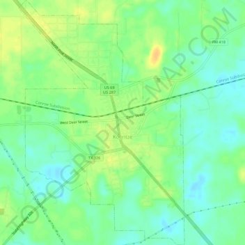
Name: Kountze topographic map, elevation, terrain.

Location: Kountze, Hardin County, Texas, United States (30.35098 -94.33548 30.39766 -94.29873)

Average elevation: 22 m

Minimum elevation: 10 m

Maximum elevation: 37 m

Gear up for your next adventure:

🧭Compass - Navigation compasses for outdoor exploration
🕯️Emergency Whistles - Safety whistles for hiking
🚁Camera Drones with GPS - Capture aerial views of the landscape to compare with topo maps
Outdoor Coffee Makers - Enjoy quality coffee at the summit of your favorite peak
📱Shockproof Phone Cases - Extra protection for your smartphone against drops on rocky terrain

As an Amazon Associate, this site earns from qualifying purchases at no extra cost to you.