
Make a donation
Gear up for your next adventure:
As an Amazon Associate, this site earns from qualifying purchases at no extra cost to you.
Tarimoro topographic map
Click on the map to display elevation.
Make a donation
Gear up for your next adventure:
As an Amazon Associate, this site earns from qualifying purchases at no extra cost to you.
About this map
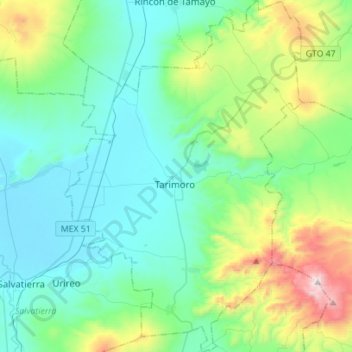
Name: Tarimoro topographic map, elevation, terrain.
Location: Tarimoro, Guanajuato, Mexico (20.16154 -100.84311 20.42403 -100.65360)
Average elevation: 2,032 m
Minimum elevation: 1,744 m
Maximum elevation: 3,107 m
Make a donation
Gear up for your next adventure:
As an Amazon Associate, this site earns from qualifying purchases at no extra cost to you.
Other topographic maps
Click on a map to view its topography, its elevation and its terrain.
Irapuato
Mexico > Guanajuato > Irapuato
It has a hot semi-arid climate (Köppen climate classification: BSh) bordering on a humid subtropical climate (Köppen climate classification: Cwa) with an average temperature of 20 °C (68 °F). The large majority of rainfall occurs from June - September. It is at an altitude above sea level of 1,724 meters…
Average elevation: 1,763 m
San Francisco del Rincón
Mexico > Guanajuato > San Francisco del Rincón
The settlement was founded as San Francisco del Tule on January 21, 1607 by a group of families of the Purépecha and Hñähñu (Otomi) ethnicities. It was declared a villa (town) on September 6, 1865 and a city on March 27, 1867. It is located at 21°01′22″N 101°51′36″W / 21.02278°N…
Average elevation: 1,767 m
Guanajuato City
Mexico > Guanajuato > Municipio de Guanajuato
Although only one out of every 100 bodies interred in the cemetery became naturally mummified, the concentration of this phenomenon has led to theories about how they have come about. Some believe that they are the result of people who had been buried alive, after being mistakenly declared dead. These people,…
Average elevation: 2,182 m
Make a donation
Gear up for your next adventure:
As an Amazon Associate, this site earns from qualifying purchases at no extra cost to you.
Silao
Mexico > Guanajuato > Silao de la Victoria
Silao is located in the Mexican state of Guanajuato. It is situated 100° 25´ 59´´ longitude west of the Greenwich meridian and 20° 56' 24 latitude north. Its altitude is 1,780 meters above sea level.
Average elevation: 1,877 m
Dolores Hidalgo
Mexico > Guanajuato > Dolores Hidalgo
It is located at 21°10′N 100°56′W / 21.17°N 100.93°W / 21.17; -100.93, at an elevation of about 1,980 meters (6,500 feet) above sea level. In the census of 2005 the city had a population of 54,843, while the municipality had 134,641 inhabitants. The city lies directly in the center of the…
Average elevation: 1,938 m
Guanajuato City
Mexico > Guanajuato > Municipio de Guanajuato
Although only one out of every 100 bodies interred in the cemetery became naturally mummified, the concentration of this phenomenon has led to theories about how they have come about. Some believe that they are the result of people who had been buried alive, after mistakenly declared dead. These people,…
Average elevation: 2,182 m
Make a donation
Gear up for your next adventure:
As an Amazon Associate, this site earns from qualifying purchases at no extra cost to you.
Make a donation
Gear up for your next adventure:
As an Amazon Associate, this site earns from qualifying purchases at no extra cost to you.
Guanajuato City
Mexico > Guanajuato > Municipio de Guanajuato
Although only one out of every 100 bodies interred in the cemetery became naturally mummified, the concentration of this phenomenon has led to theories about how they have come about. Some believe that they are the result of people who had been buried alive, after mistakenly declared dead. These people,…
Average elevation: 2,182 m
San Miguel de Allende
Mexico > Guanajuato > San Miguel de Allende > San Miguel de Allende
Average elevation: 2,029 m
Make a donation
Gear up for your next adventure:
As an Amazon Associate, this site earns from qualifying purchases at no extra cost to you.
Make a donation
Gear up for your next adventure:
As an Amazon Associate, this site earns from qualifying purchases at no extra cost to you.
Dolores Hidalgo
Mexico > Guanajuato > Dolores Hidalgo
It is located at 21°10′N 100°56′W / 21.17°N 100.93°W / 21.17; -100.93, at an elevation of about 1,980 meters (6,500 feet) above sea level. In the census of 2005 the city had a population of 54,843, while the municipality had 134,641 inhabitants. The city lies directly in the center of the…
Average elevation: 1,938 m
Irapuato
Mexico > Guanajuato > Irapuato
It has a humid subtropical climate (Cwa in the Köppen climate classification) with an average temperature of 20 °C (68 °F). The large majority of rainfall occurs from June - September. It is at an altitude above sea level of 1,724 meters (5,656 ft).
Average elevation: 1,763 m
Make a donation
Gear up for your next adventure:
As an Amazon Associate, this site earns from qualifying purchases at no extra cost to you.