Geolocate

Hanover topographic map

Click on the map to display elevation.

About this map

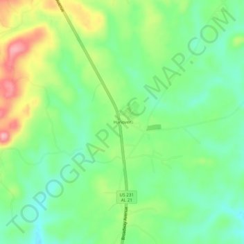
Name: Hanover topographic map, elevation, terrain.

Location: Hanover, Coosa County, Alabama, United States (32.98484 -86.22247 33.02484 -86.18247)

Average elevation: 233 m

Minimum elevation: 184 m

Maximum elevation: 318 m

Other topographic maps

Click on a map to view its topography, its elevation and its terrain.

Goodwater

United States > Alabama > Coosa County

Average elevation: 251 m

Kellyton

United States > Alabama > Coosa County

Average elevation: 225 m

Rockford

United States > Alabama > Coosa County

Average elevation: 221 m

Gear up for your next adventure:

🧊Insulated Stainless Steel Flasks - Keep water cold for 24 hours in the heat or coffee hot in the cold
🚁Camera Drones with GPS - Capture aerial views of the landscape to compare with topo maps
🛌Compact Down Sleeping Bags - Warmth without the bulk, ideal for backcountry camping
🩹Blister Prevention Tape - Apply to friction points before they become painful sores
🦟Heavy Duty Insect Repellent - Essential protection against flies, mozzies, and march flies

As an Amazon Associate, this site earns from qualifying purchases at no extra cost to you.