
Muskegon topographic map
Interactive map
Click on the map to display elevation.
About this map
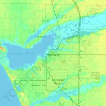
Name: Muskegon topographic map, elevation, terrain.
Location: Muskegon, Muskegon County, Michigan, United States (43.20236 -86.34820 43.26970 -86.16937)
Average elevation: 188 m
Minimum elevation: 175 m
Maximum elevation: 219 m
Other topographic maps
Click on a map to view its topography, its elevation and its terrain.
Casnovia Township
United States > Michigan > Muskegon County
Casnovia Township, Muskegon County, Michigan, 49303, United States
Average elevation: 240 m
Twin Lake
United States > Michigan > Muskegon County
Twin Lake, Dalton Township, Muskegon County, Michigan, United States
Average elevation: 210 m
Patterson Park
United States > Michigan > Muskegon County
Patterson Park, 5995, Ravenna Township, Muskegon County, Michigan, 49451, United States
Average elevation: 207 m
Mona Lake Channel
United States > Michigan > Muskegon County > Norton Shores
Mona Lake Channel, Norton Shores, Muskegon County, Michigan, 49441, United States
Average elevation: 184 m
South Whitehall
United States > Michigan > Muskegon County > Whitehall
South Whitehall, Whitehall, Muskegon County, Michigan, 49437, United States
Average elevation: 191 m
Fruitport
United States > Michigan > Muskegon County
Fruitport, Fruitport Charter Township, Muskegon County, Michigan, United States
Average elevation: 189 m
Montague Township
United States > Michigan > Muskegon County
Montague Township, Muskegon County, Michigan, United States
Average elevation: 197 m
Maple Grove
United States > Michigan > Muskegon County > Montague
Maple Grove, Montague, Muskegon County, Michigan, 49437, United States
Average elevation: 189 m
Wolf Lake
United States > Michigan > Muskegon County
Wolf Lake, Egelston Township, Muskegon County, Michigan, United States
Average elevation: 205 m
Egelston Township
United States > Michigan > Muskegon County
Egelston Township, Muskegon County, Michigan, United States
Average elevation: 202 m
Holton
United States > Michigan > Muskegon County
Holton, Holton Township, Muskegon County, Michigan, 49425, United States
Average elevation: 224 m
Mona Lake
United States > Michigan > Muskegon County > Norton Shores
Mona Lake, Norton Shores, Muskegon County, Michigan, United States
Average elevation: 189 m
Big Blue Lake
United States > Michigan > Muskegon County
Big Blue Lake, Blue Lake Township, Muskegon County, Michigan, United States
Average elevation: 204 m
Montague
United States > Michigan > Muskegon County
Montague, Muskegon County, Michigan, United States
Average elevation: 191 m
Whitehall
United States > Michigan > Muskegon County
Whitehall, Muskegon County, Michigan, United States
Average elevation: 191 m
Laketon Township
United States > Michigan > Muskegon County
Laketon Township, Muskegon County, Michigan, 49445, United States
Average elevation: 187 m
Fruitport Charter Township
United States > Michigan > Muskegon County
Fruitport Charter Township, Muskegon County, Michigan, 49415, United States
Average elevation: 194 m
P.J. Hoffmaster State Park
United States > Michigan > Muskegon County > Muskegon Heights
P.J. Hoffmaster State Park, Muskegon Heights, Spring Lake Township, Muskegon County, Michigan, 49441, United States
Average elevation: 186 m
Fruitland Township
United States > Michigan > Muskegon County
Fruitland Township, Muskegon County, Michigan, United States
Average elevation: 193 m
Ravenna Township
United States > Michigan > Muskegon County
Ravenna Township, Muskegon County, Michigan, 49451, United States
Average elevation: 207 m
Ravenna
United States > Michigan > Muskegon County
Ravenna, Ravenna Township, Muskegon County, Michigan, United States
Average elevation: 210 m
Norton Shores
United States > Michigan > Muskegon County
Norton Shores, Muskegon County, Michigan, 49444, United States
Average elevation: 186 m